


 本文深入探讨了如何使用算法解决城市天际线问题,通过给出建筑物的位置和高度,输出整个城市的独特轮廓。重点介绍了算法的实现过程,包括如何处理建筑物的数据结构、排序、堆操作等关键步骤,最终生成清晰的城市天际线轮廓。
原链接https://leetcode.com/problems/the-skyline-problem/
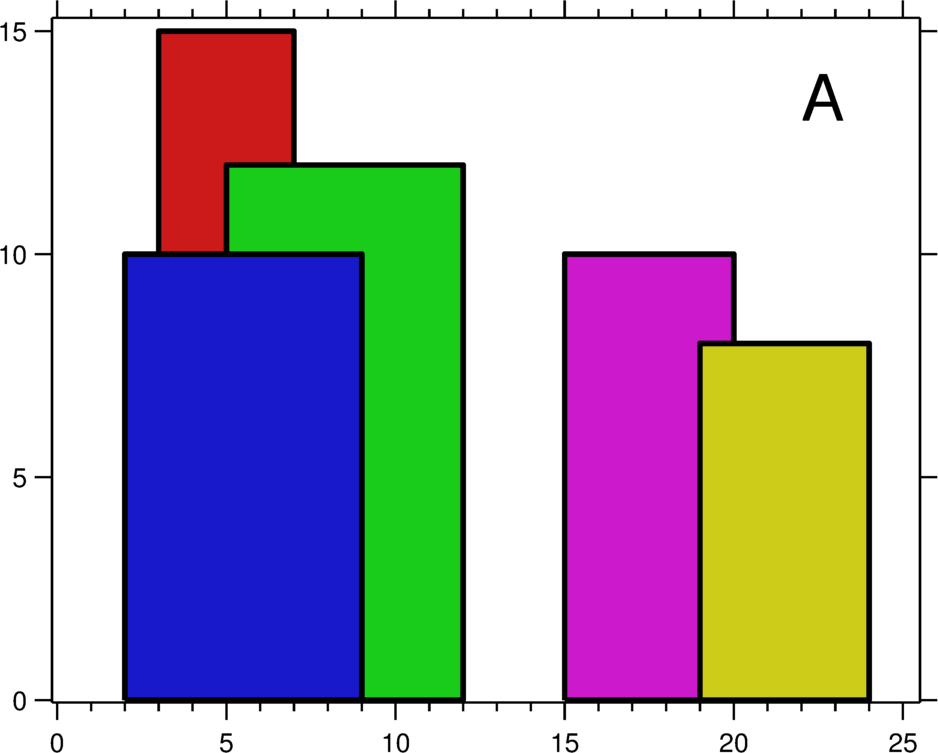
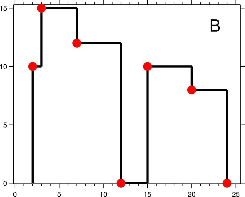
A city's skyline is the outer contour of the silhouette formed by all the buildings in that city when viewed from a distance. Now suppose you aregiven the locations and height of all the buildings as shown on a cityscape photo (Figure A), write a program tooutput the skyline formed by these buildings collectively (Figure B).
The geometric information of each building is represented by a triplet of integers [Li, Ri, Hi], where Li and Ri are the x coordinates of the left and right edge of the ith building, respectively, and Hi is its height. It is guaranteed that 0 ≤ Li, Ri ≤ INT_MAX, 0 < Hi ≤ INT_MAX, and Ri - Li > 0. You may assume all buildings are perfect rectangles grounded on an absolutely flat surface at height 0.
For instance, the dimensions of all buildings in Figure A are recorded as: [ [2 9 10], [3 7 15], [5 12 12], [15 20 10], [19 24 8] ] .
The output is a list of "key points" (red dots in Figure B) in the format of [ [x1,y1], [x2, y2], [x3, y3], ... ] that uniquely defines a skyline. A key point is the left endpoint of a horizontal line segment. Note that the last key point, where the rightmost building ends, is merely used to mark the termination of the skyline, and always has zero height. Also, the ground in between any two adjacent buildings should be considered part of the skyline contour.
For instance, the skyline in Figure B should be represented as:[ [2 10], [3 15], [7 12], [12 0], [15 10], [20 8], [24, 0] ].
Notes:
- The number of buildings in any input list is guaranteed to be in the range
[0, 10000]. - The input list is already sorted in ascending order by the left x position
Li. - The output list must be sorted by the x position.
- There must be no consecutive horizontal lines of equal height in the output skyline. For instance,
[...[2 3], [4 5], [7 5], [11 5], [12 7]...]is not acceptable; the three lines of height 5 should be merged into one in the final output as such:[...[2 3], [4 5], [12 7], ...]
<span style="font-size:14px;">class Solution {
public:
    //参考自 http://www.cnblogs.com/easonliu/p/4531020.html
    vector<pair<int, int> > getSkyline(vector<vector<int> >& buildings) {
		typedef pair<int, int>pii;
		multiset<int> heap;
		vector<pii> height;
		vector<pii> ans;
		for (auto &b : buildings) {
			height.push_back(pii(b[0], -b[2]));
			height.push_back(pii(b[1], b[2]));
		}
		sort(height.begin(), height.end());
		heap.insert(0);
		int pre = 0, cur = 0;
		for (auto &h : height) {
			if (h.second < 0)
				heap.insert(-h.second);
			else
				heap.erase(heap.find(h.second));
			cur = *heap.rbegin();
			if (cur != pre) {
				ans.push_back(pii(h.first, cur));
				pre = cur;
			}
		}
		return ans;
	}
};</span>


 2926
2926

 被折叠的 条评论
为什么被折叠?
被折叠的 条评论
为什么被折叠?
 到【灌水乐园】发言


